Background and Policy Promotion
The Water Resources Agency (WRA) promulgated the “Format for River Management Planning and Documentation” in 2019. Since then, the policy has undergone a series of legislative developments including flood runoff allocation, watershed adaptation, and enhanced public participation and communication mechanisms.
In response to evolving needs and feedback from users and stakeholders, the format has been continuously reviewed and revised. The Regional Water Resources Office convened experts from river management branches and academia, holding 15 working and consultation meetings to revise the format. The revised version, titled “Format for River Management Planning and Documentation (2025 Revised Edition)”, was officially issued by WRA in September 2025.
Key Revisions
- Multi-adaptive approach for controversial reaches
- In sections where consensus on flood control strategies cannot be reached, short-term management can adopt a multi-method flood adaptation strategy.
- Public participation guidelines
- Includes key considerations and recommended forms for engaging public involvement during planning.
- Review of cross-river structures
- New procedures added for evaluating structures such as bridges and pipelines crossing river channels.
- Zoning principles and reference illustrations (See Figure 1)
- Provides schematic examples of how to delineate zoning boundaries, such as at main and tributary junctions.
- Updated base maps for official mapping products (See Figure 2)
- Official maps are now based on topographic overlays, with vertex coordinate numbers and tabular indexes added for clarity and consistency.
- New aerial imagery guidelines (See Figure 3)
- Aerial footage now must clearly display designated features and symbols, such as levees, erosion points, and important landmarks.
- Revised forms and examples
- Standard tables have been revised with additional sample templates for user reference.
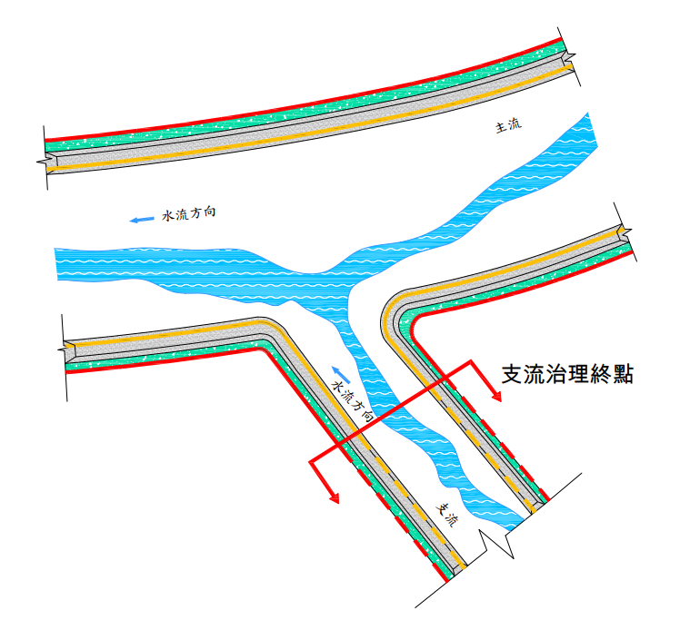
Figure 1: Example zoning schematic at main-tributary junction
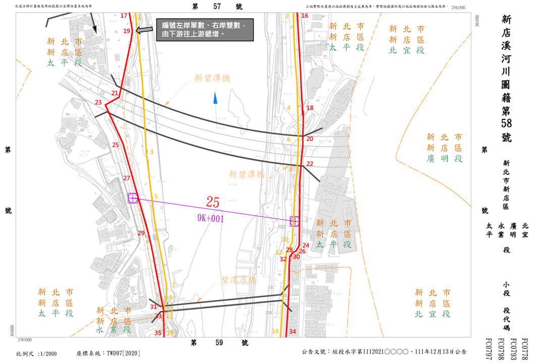
Figure 2: Updated official map using topographic overlay with vertex IDs
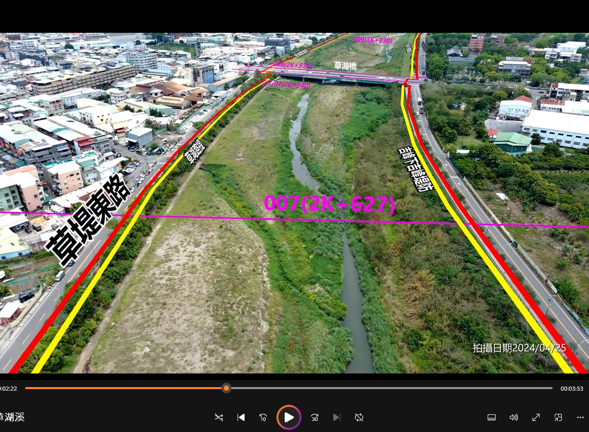
Figure 3: Aerial footage display specifications with labels and annotations
Integrated Coastal Protection Planning and Application of Climate Change Adaptation
Rolling Review of Coastal Protection Zoning
The first- and second-tier coastal protection plans were successively promulgated by the Ministry of the Interior in 2020 and 2021.
Following this, the Regional Water Resources Office aligned with the Ministry’s "First Comprehensive Review of the Integrated Coastal Management Plan", which is scheduled for formal promulgation in 2025. This plan officially incorporates the "Climate Change Adaptation Strategy" into the Coastal Protection Integration Planning Guidelines, alongside revised zoning principles for storm surge inundation potential.
In future updates or reviews of coastal protection plans, competent agencies will not only assess the current functions of protective structures but also be required to:
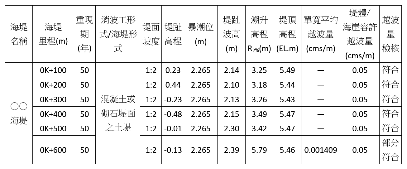
- Evaluate Weak Points in Coastal Levees under Climate Change Scenarios
- Systematic inspections should consider projected increases in wave conditions and sea level rise, which may compromise levee integrity.
- A sample inspection form for overtopping volumes under climate change scenarios is shown in Table 1.
Table 1: Sample form for levee overtopping review under climate change scenarios
- Delineate Buffer Zones Based on Storm Surge Scenarios
- Areas identified as high-risk for storm surge inundation under future climate scenarios (see Figure 4) will be designated as land-side buffer zones in coastal protection plans.
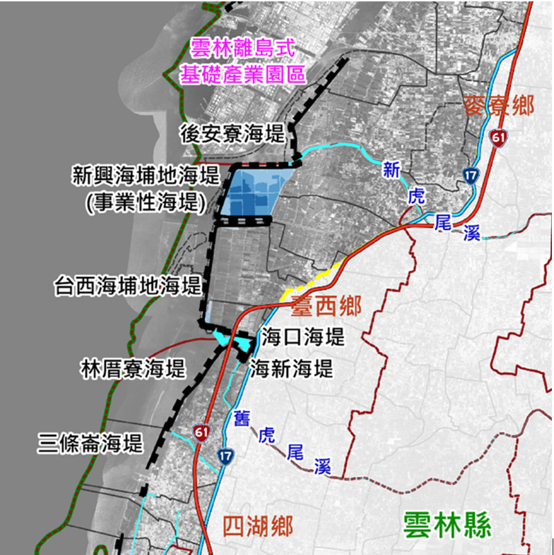
Figure 4: Depth distribution of storm surge inundation under climate change (Yunlin example)
- Establish Management Rules Within Protection Zones
- Clear definition of prohibited and compatible land uses within protection zones to ensure effective land management and coastal safety.
Application of Oceanographic Increment Data under Climate Change
To ensure consistency in scientific data sources, it is recommended that coastal protection-related climate change data be primarily sourced from:
- TCCIP (Taiwan Climate Change Projection and Information Platform Project)
- Offers downscaled climate data and value-added products.
However, due to significant spatial variation in tidal levels and the limited applicability of the platform’s data in engineering planning, the Regional Office collaborated with technical partners to obtain customized datasets, including:
- 50-year return period oceanographic increments at specific points
- Comprehensive review of coastal protection water levels across Taiwan (see Figure 5)
- Calculation of projected changes in storm surge deviation rates (see Figure 6)
These results will serve as references for the future reviews and updates of integrated coastal protection plans.
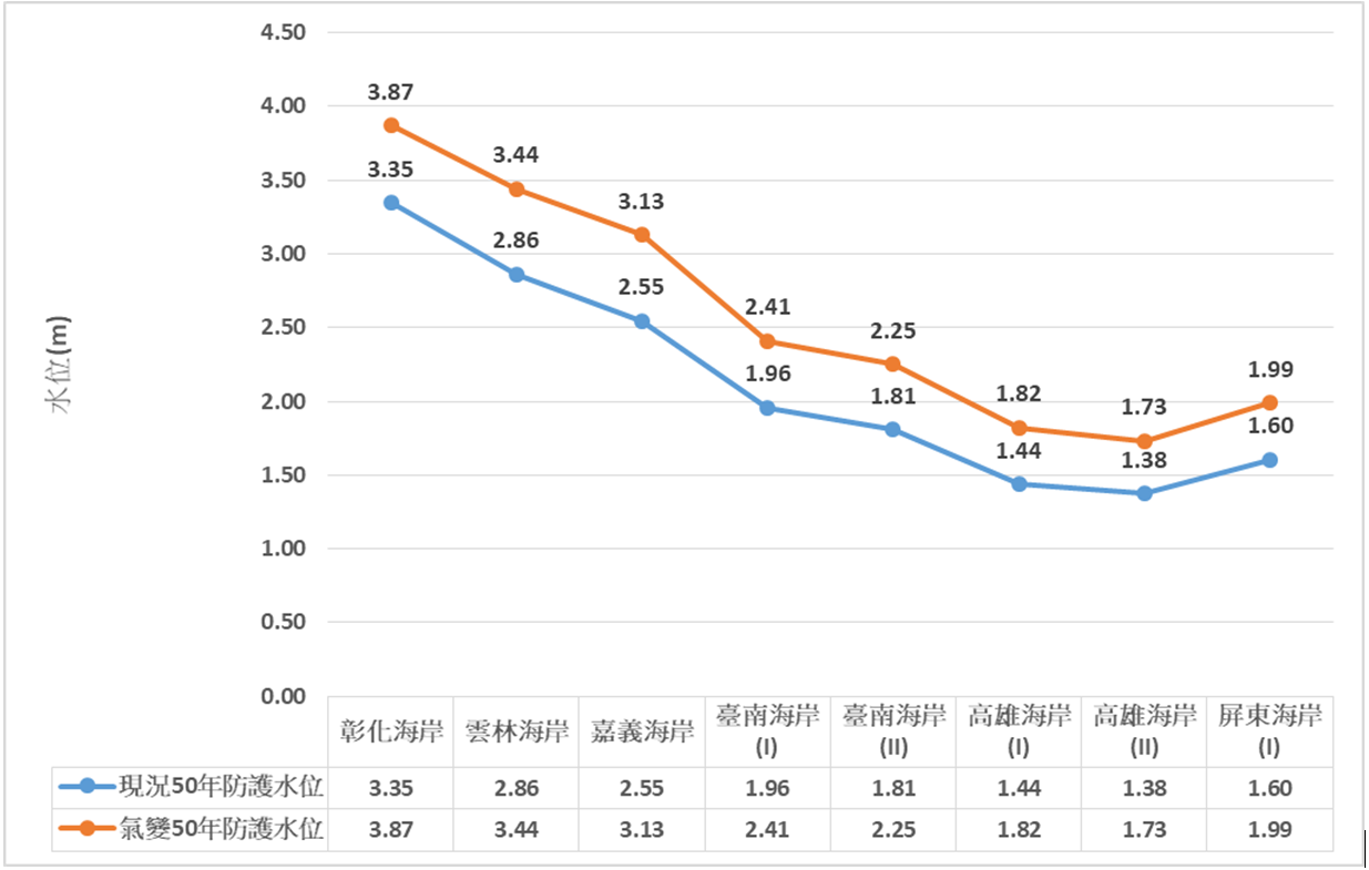
Figure 5: Projected protective water levels under present and future climate conditions
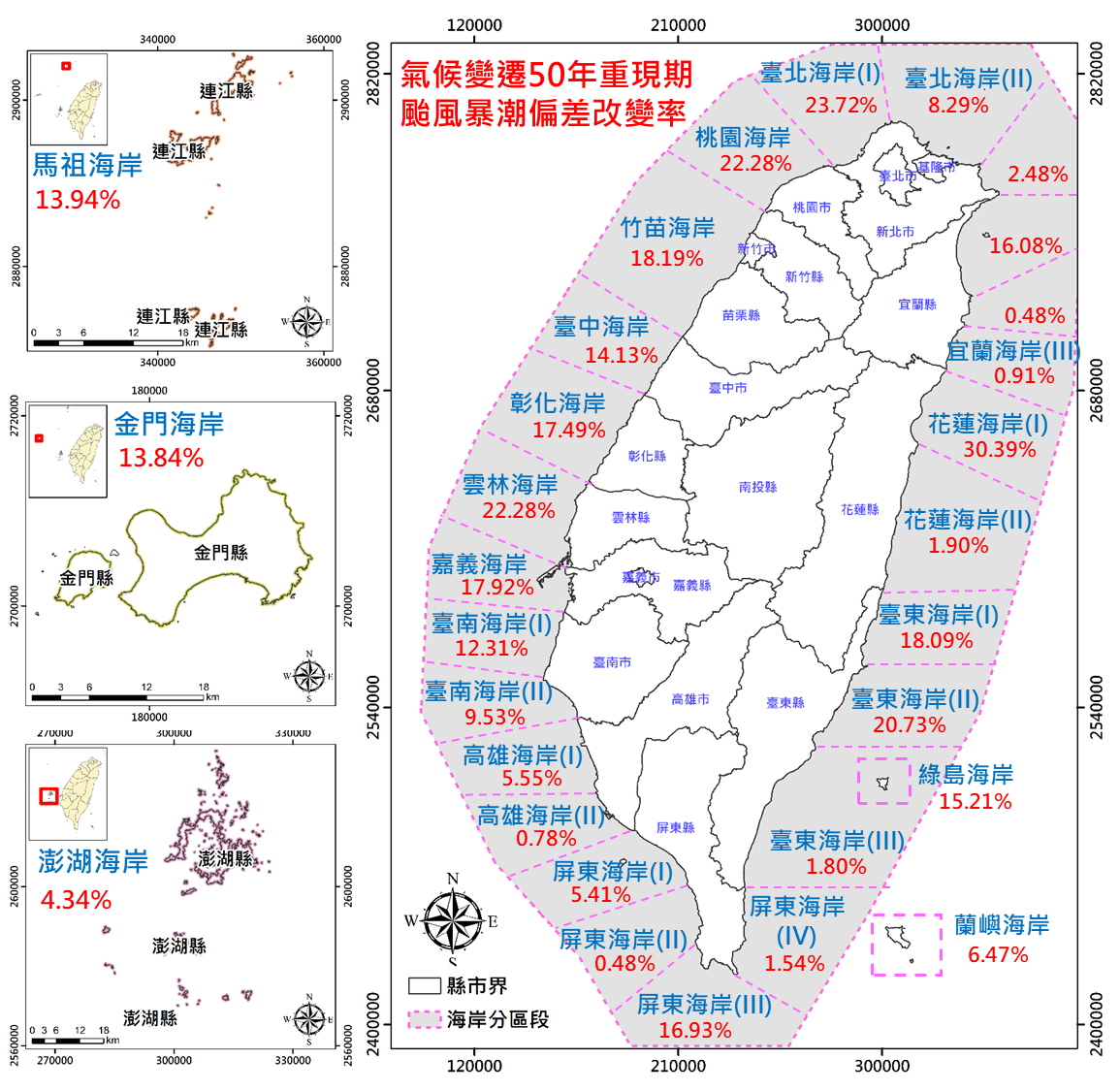
Figure 6: Regional map of 50-year return period storm surge deviation rates under climate change