I. Regulation Planning of Major and Minor Rivers in Taiwan
- In October 1967, the River Governance Planning Corps was established (the predecessor of the Water Resources Planning Branch).
- Governance began with comprehensive river planning—including flood confinement, flood guidance, flood storage, flood diversion, and flood avoidance—to formulate river governance plans that would be implemented after review and public announcement.
- These plans provided key foundations for flood-control works under the Twelve/Fourteen Major Economic Construction Projects and the Six-Year National Construction Program.
II. Environment Building Plan of Important Rivers
- Launched 2004–2008 in line with the national policy “Challenge 2008—Ecological River Management and Waterfront Amenities.”
- Objectives: build fundamental river datasets, improve river environments, maintain normal river functions, create nature-rich waterside spaces and recreation, and enhance biodiversity to achieve disaster-mitigation goals and a healthy river environment.
- Phase II (2009–2014) continued these efforts, aligned with the “2015 Economic Development Vision” toward a prosperous, just, and sustainable living environment.
III. Integrated Regulation Plan of the Keelung River
- The Keelung River, a major tributary of the Tamsui River, meanders through valleys with narrow, low-lying plains. Proximity to the Taipei metro area led to intensive development on both banks, causing severe land-water conflicts.
- Orographic effects produce two heavy-rain centers—Huoshaoliao in the upper basin and Yangmingshan downstream—making typhoon-induced cloudbursts and flash floods common, with Xizhi and Wudu particularly hard-hit.
- In November 2000, WRA proposed the Yoanshanzi Flood Diversion project to reduce downstream flows via diversion. However, by itself it could not achieve protection at the 200-year return-period peak flow.
- Therefore, the Integrated Regulation Plan of the Keelung River was developed and approved by the Executive Yuan in May 2001; implementation followed (see Fig. 1).
- Early works were completed by end-March 2002, but provided only 10-year return-period protection due to highly developed banks, constrained channel, and limited flood storage.
- Under the premise of advancing the Yoanshanzi diversion, the plan (approved April 2002) set out measures to address flooding:
- Structural: flood protection or storage, diversion, conveyance enhancement, detention, tributary interception, and channel dredging.
- Non-structural: flood insurance for low-lying areas, land-use planning for flood-prone zones, and delineation/regulation of floodplains (see Photos 1 and 2).
IV. Regulation Project of Flood-Prone Areas
- To resolve inundation in subsidence zones, low-lying areas, and urban districts and safeguard households and the economy, the Ministry of Economic Affairs in 2005 proposed a county/city-scale, systemwide approach (rivers under local jurisdiction, regional drainage, and industrial seawalls), modeled on the Keelung River experience; it received the Executive Yuan’s in-principle consent.
- From 2006 to 2013), planning works were completed for: Dezihkou River, Nankan River, Yuanli River, Linbian River, Taimali River, Zhiben River, Lijia River, and Meilun River.
V. Improvement and Adaptation Plan for Integrated Basins Administered by the Central Government
- Planned period: 2021–2026.
- Uses climate-change risk scenarios as stress tests for basin flood-protection capacity, identifying high/medium/low-risk areas and introducing risk-management concepts with adaptation measures.
- Also emphasizes habitat conservation, waterfront landscape, water culture and history, and natural landscape creation to enhance waterfront environmental quality.
- Vision: build flood resilience and a vibrant aqueous environment.
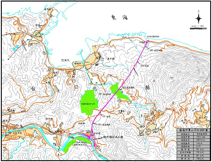
Fig. 1 Flood-diversion route alignment in the 2002 engineering design.
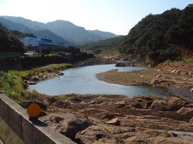
Photo 1. Pre-construction photograph of the Yuanshanzi Flood Diversion on the Keelung River.
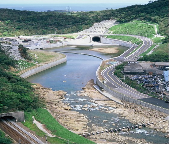
Photo 2. Post-construction photograph of the Yuanshanzi Flood Diversion on the Keelung River.