Taiwan is frequently affected by typhoons and heavy rainfall, often leading to flooding disasters that threaten lives and cause property losses. To support governments at all levels in flood disaster prevention and emergency response, the government has implemented the Potential Inundation Maps Project. These maps simulate potential inundation depths and affected areas under different rainfall conditions.
Between 2014 and 2016, the maps underwent the second round of updates (the Third-Generation Potential Inundation Maps). However, due to changes in topography and improvements in flood simulation technologies and data quality in recent years, it has become necessary to update the maps. The update process includes collecting new topographic and geomorphic data, applying advanced modeling software, building flood models, and verifying results against historical typhoon and flood events. Only after multi-stage reviews and evaluations can the official scenario-based Potential Inundation Maps and related datasets be produced.
The project consists of two main phases:
Phase I: Data Collection and Model Development
Tasks include collecting and analyzing hydrological, topographic, and oceanographic data, as well as building the inundation model.
Phase II: Model Simulation and Results Production
Tasks include model calibration and validation, scenario simulations, local workshops or stakeholder interviews, report preparation, and the production of maps and numerical datasets.
Unlike the third generation, which used the SOBEK model (modeling rainfall as entering one-dimensional river channels before overflowing to the land surface), the Fourth-Generation Potential Inundation Maps adopt the Delft3D FM 1D2D model developed by Deltares in the Netherlands. This model simulates overland flow from rainfall directly on the surface, coupled with river channel processes, providing a more realistic representation of rainfall–runoff dynamics. Additionally, Delft3D FM 1D2D utilizes an unstructured grid system and supports multi-core computation, significantly enhancing calculation efficiency.
For topographic input, the fourth-generation maps use HyDEM, jointly developed by the Water Resources Agency and the Ministry of the Interior. HyDEM provides high-resolution spatial data enriched with hydraulic details such as levee lines, coastline boundaries, and water bodies. These features enable more accurate spatial definitions of one- and two-dimensional components in the model, resulting in simulations that better reflect real-world conditions.
Finally, the simulation results can be presented dynamically through the Multi-Dimensional Service Platform of the National Land Surveying and Mapping Center, Ministry of the Interior. This allows both the public and experts to access more detailed information on the computational process and results.
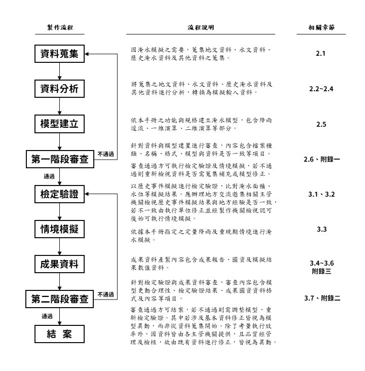
Figure 1. Production Flowchart of Flood Potential Maps